FetchSRTM
From PathlossWiki
Description
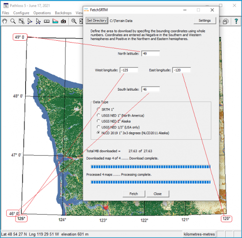
The FetchSRTM tool downloads SRTM and NED terrain data. The tool allows the user to batch download larger areas, then saves and decompresses the data to a user defined location.
The tool can be downloaded at https://www.pathloss.net/fssetup.exe
How To use the tool
- Click Set directory to set the location of the downloaded files. This is the location where the program will decompress and save the files
- Enter the bounding coordinates of the area of interest. The graphic below shows an example of how to read the bounding coordinates from the Pathloss Network grid. The coordinates are entered as whole numbers (no decimal or minutes and seconds) Be sure to use negative values in the western and southern hemispheres.
- Select the Data type you want to download. The USGS 1/3" NED files are large and can a long time to download
- Click Fetch to start the download.
- If you have selected 1" SRTM as the data type, you will be prompted to enter your Earthdata login credentials. A cookie will be stored and subsequent downloads will not require the login. The FetchSRTM tool does not store your Earthdata user name or password.
- The download will begin and download progress is displayed. Previously downloaded data will not be overwritten, these files are skipped.
- The files will be automatically unzipped and saved in the directory that was selected.
- NED 1/3" files are large and can take considerable time to download.
- NLCD files require post processing and can take a considerable amount of time to download and convert.
Changelog
Version 1.0.1.7 December 1, 2023
- Updated NLCD to the 2021 data. Users existing NLCD data will be untouched, a new folder called NLCD2021 is created. NLCD for Alaska is still 2011.
Version 1.0.1.6 November 2, 2023
- Fixed Pathloss 4 compatibility issue with NED 1" and 1/3".
Version 1.0.1.5 August 21, 2023
- Updated NED 1" and NED1/3" to always use the latest data. The files are downloaded in GeoTIFF format and converted to GridFloat.
Version 1.0.1.4 August 11, 2022
- Updated SRTM server
Version 1.0.1.3 August 10, 2021
- Updated 1/3 NED file locations
Version 1.0.1.2 July 29, 2021
- Updated NLCD to NLCD2019 for CONUS and added NLCD2011 for Alaska
Version 1.0.1.1 February 28, 2020
- Added USGS NLCD2016 data source. The files have been re-projected and cover a 3x3 degree area. You will need the latest Pathloss 5.1 update in order to use this data.
Version 1.0.1.0 November 5, 2019
- Added USGS staged data from AWS
- Fixed bug when downloading at 0 degrees longitude
Version 1.0.0.9 June 17, 2019
- Fixed bug that skipped some 1/3" NED files
- Added multi-threaded support
- Added additional progress bar to show file processing
Version 1.0.0.8 March 15, 2019
- Added support for proxy servers
- File directory is now saved
- Downloaded files are organized by type in separate directories
- Added cancel option without closing program
Version 1.0.0.7 January 15, 2019
- Fixed naming convention problem with NLCD 3x3 degree files
Version 1.0.0.6 January 9, 2019
- Added NLCD data in BIL format. These are downloaded in 3x3 degree blocks
- Alternately named NED files are now automatically detected and downloaded
Version 1.0.0.5 December 18, 2018
- Fixed expired cookie bug
Version 1.0.0.4 April 12, 2018
- Added option to download Ned 2" data for Alaska
- Added option to use older files names. By default the program will download the newest files. If there no maps found then this option will use the older map names.
Version 1.0.0.3 January 5, 2018
- Fixed USGS SRTM file locations
Version 1.0.0.2 May 5, 2017
- Fixed expired cookies not being updated
- Fixed the download counter
Version 1.0.0.1 Nov 10, 2016
Initial release
